This website uses cookies so that we can provide you with the best user experience possible. Cookie information is stored in your browser and performs functions such as recognising you when you return to our website and helping our team to understand which sections of the website you find most interesting and useful.

Catch, YT

Highlights
- 117 km2 property located 56 km southeast of Carmacks in an underexplored part of central Yukon;
- All-season highway and high-voltage powerline 10 km from the property;
- Inaugural 2023 diamond drilling returned 116.60 m of 0.31% copper with 0.30 g/t gold from a new greenfield copper-gold porphyry discovery;
- Extensive copper and gold soil anomalism, including a 5,000 x 500 m copper and gold soil anomaly;
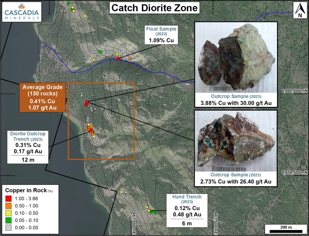
- Rock samples have peak values of 3.88% copper, 30.0 g/t gold, 228 ppm molybdenum, and 89 g/t silver; and
- Results from 3 additional diamond drill holes are pending.
The 117 km2 Catch Property is located 56 km southeast of Carmacks within the traditional territory of the Little Salmon Carmacks First Nation. The property is 10 km from an all-season highway and powerline and is accessible by float plane and helicopter. The first two diamond drill holes ever completed on the property returned a highlight of 116.60 m of 0.31% copper with 0.30 g/t gold at the Diorite Zone target, confirming a significant new copper-gold porphyry discovery.
The Catch Property exhibits extensive copper and gold soil geochemistry anomalism, including a 5,000 x 500 m zone of anomalous copper and gold. Two zones of copper and gold mineralization have been identified at surface, the Main Zone and Diorite Zone. The Main Zone has an average rock grade of 0.32% copper with 0.70 g/ t gold in 258 rocks collected at surface over a 500 x 500 m area and an underlying 1,000 x 600 x 400 m coincident chargeability and resistivity high. The Diorite Zone has an average rock grade of 0.41% copper with 1.07 g/t gold in 130 rocks collected at surface over a 500 x 500 m area and has an underlying 1,000 x 500 x 300 m chargeability high.

Catch Diamond Drilling Results

The inaugural diamond drill program at the Catch Property was completed in fall 2023. A total of five holes were drilled, totaling 2,462 m. The first two holes were completed at the Diorite Zone. Hole CA-23-001 ended at 511.83 m depth and Hole CA-23-002 ended at 554.00 m depth, with sulphide mineralization (pyrite-pyrrhotite-chalcopyrite) observed to the end of both holes. Both holes were targeting a broad Induced Polarization (“IP”) chargeability anomaly at depth, underlying coincident high-grade surface mineralization, within a pronounced magnetic anomaly. An additional three holes were drilled at the Main Zone, located 2 km north, and results from these holes are pending.
Hole CA-23-002 intersected 116.60 m of 0.31% copper and 0.30 g/t gold from 356.00 m downhole, within a broader interval of 435.00 m of 0.16% copper and 0.09 g/t gold. Hole CA-23-001 intersected 45.83 m of 0.30% copper and 0.15 g/t gold from surface, within a broader interval of 333.87 m of 0.13% copper. These holes were drilled 160 m apart, in the middle of coincident 1,200 x 600 m chargeability and 800 x 600 m magnetic anomalies that are just beginning to be tested.
Table 1: 2023 Catch Assays Result Summary
| Drill Hole | From (m) | To (m) | Interval (m)* | Copper (%) | Gold (g/t) |
| CA -23-001 | 14.00 | 347.87 | 333.87 | 0.13 | 0.04 |
| incl. | 14.00 | 59.83 | 45.83 | 0.30 | 0.15 |
| CA -23-002 | 80.00 | 515.00 | 435.00 | 0.16 | 0.09 |
| incl. | 356.00 | 472.60 | 116.60 | 0.31 | 0.30 |
| and incl. | 357.93 | 362.00 | 4.07 | 0.51 | 6.03 |
| and incl. | 407.00 | 472.60 | 65.60 | 0.40 | 0.13 |
Drilling has yet to intersect significant potassic alteration, suggesting there is potential to discover higher copper and gold grades in the untested core of the porphyry system. Additional drilling will be required to vector towards this core, with a robust follow-up program planned to commence in spring 2024.
Table 2: 2023 Catch Drill Hole Collars**
| Drill Hole | Easting (m) | Northing (m) | Azimuth (°) | Dip (°) | Depth (m) |
| CA-23-001 | 482,726 | 6,859,800 | 130.4 | -60 | 511.83 |
| CA-23-002 | 482,702 | 6,859,958 | 129.7 | -65 | 554.00 |

Catch Geology and Mineralization
The Catch Property lies within the Stikine Terrane and is immediately adjacent to the 1,000+ km long, deep seated, crustal scale strike-slip Teslin-Thibert fault. The Stikine Terrane is characterized by Late Triassic to early Jurassic volcanic-plutonic arc complexes that are well-endowed with copper-gold-molybdenum porphyries including the Red Chris, Schaft Creek, Kemess, KSM and Galore Creek deposits and mines.
The Catch Property is mostly underlain by augite phyric basalt of the Semenof Formation, centered on a 7 x 3 km regional magnetic high. Mineralization is associated with propylitic to sericitic alteration of basalt and lesser diorite, intrusion breccias and hydrothermal breccias. Locally there is intense silicification, brecciation and up to 10% disseminated to blebby pyrite, chalcopyrite and trace bornite and pyrrhotite. Secondary copper minerals including malachite, azurite and tenorite are widespread at surface, and coat fracture surfaces, and are often associated with gypsum.
The geology, alteration and mineralization observed throughout the Catch Property are all indicative of a nearby copper-gold±molybdenum bearing porphyry system.
Technical Reports
| May 9, 2023 | Catch Property Technical Report |
Catch Maps & Figures


CATCH CORE PHOTOS


Catch Rock Photos


